Just south of where the Missouri, Illinois, and Mississippi rivers of North America converge, there is a 175-square mile area of flat lands that extends from Alton, Illinois, south to the Kaskaskia River. Its western boundary is the Mississippi River, and the eastern boundary is a range of rocky bluffs stretching from one to seven miles from the river. This area is known as the American Bottom. The American Bottom includes seven different regions. The largest, in the central and southern parts of the American Bottom, is the ridge and swale region consisting of linear ridges of sand and long narrow swales of clay. The other six regions are the alluvial fan region, lake region, tributary Meander Belt, terrace region, aggraded cut and fill region, and the East St. Louis rise. The elevation of the floodplain varies from 415 feet above average sea level in the northern portion to about 405 feet in the southern portion. The bluffs on the eastern side rise 125-200 feet above the floodplain, but the American Bottom was not always like this. Deposition of sediments during the Wisconsin and Holocene glaciers created the many landforms of the American Bottom, including deposits of very fertile soil. The Mississippi floodplain may have risen up to 18 meters above the present level, and 30 meters of loess accumulated on top of the limestone bluffs during the Wisconsin glacial age.
It is speculated that thousands of years earlier the river was much wider. Apparently, it was one of the main channels for melting snow and ice during the ice ages. However, as the flow of the river slowed, due to the retreating glaciers, the channel filled with dirt and the bottomland was formed.
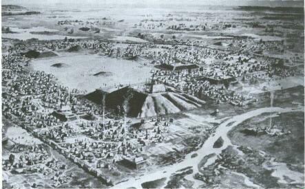
The fertile soil of the American Bottom was a very attractive feature to humans. Before the French, British, and American settlers arrived in present-day Illinois, a group of people called the Mississippians ruled part of the great floodplains of the American Bottom between the present-day cities of East St. Louis and Collinsville in Madison and St. Clair counties. Known for the earthen mounds they left behind, they were the most organizationally complex society of pre-Columbian North America. Because of the very fertile soil, agriculture became a very important part of the Mississippian culture, and farming enabled them to become a very stable society for a long period of time. The region not only had fertile soil, it also was abundant with trees. These prehistoric people used Umber for fuel and to build homes and walls.
However, mysteriously around 1250 A. D., the Mississippian society declined rapidly, and when explorers Marquette and Jolliet passed through four hundred years later, they were unaware of its existence.
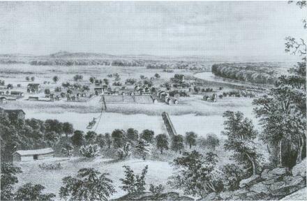
Eventually Europeans began to reach the mid-western portion of the continent. The French first reached and settled the American Bottom. In 1699, after the appointment by the Quebec Governor, the Seminary of Foreign Missions was given permission to work in the northern portion of the American Bottom. The Indian villages near and along the rivers made this a superb location for missionaries to carry out their work. In March 1699 three Seminarian priests created the Mission of the Holy Family. By May of that year a chapel and a house for the priest had been built. Eventually, other French settlers arrived and built homes around the mission. This settlement was named Cahokia, and today it is the oldest permanent settlement in the American interior.
Meanwhile, the Jesuits worked with the Iliniwek tribes, including the Kaskaskia Indians who were located between central Illinois and present-day St. Louis. When the Kaskaskia decided to move to the lower end of the American Bottom near the junction of the Kaskaskia and Mississippi rivers, the Jesuits followed them. In 1703 the French settlement of Kaskaskia was established. In time it became the largest French settlement and later Illinois’ first capital city. The towns of Prairie du Rocher and St. Phillip were also established. One of the most important economic activities while the French were in the region was farming. The French used the fertile soil of the bottomland to grow large quantities of wheat, which they used locally and exported. To protect the region, the French built Fort de Chartres. It was constructed two more times. The last time it was built with stone brought from the limestone deposits from the American Bottom bluffs.
During the Revolutionary War, soldiers under George Rogers Clark returned home and told of this rich soil and wanted it for themselves. They brought their families and settled on various locations in the rich floodplains of Illinois. The entire area became known as the American Bottom because of the gradual arrival of the English-speaking settlers. This new name helped to distinguish it from the Spanish territory on the west bank of the Mississippi River.
As the decades passed more American settlers arrived. During the first quarter of the nineteenth century, one historian described the first settlers, many of whom were from the south:
Filling in the rich bottom lands of the Ohio and Mississippi first, they soon spread over the forested portions of southern Illinois, seeking always the dense timber that testifies to good soil. There they girdled the trees, planted their corn, raised their log cabins, split rails for their worm fences, shook through regular attacks of malaria and steadily extended their civilization over a widening area.
By 1818, when Illinois became a state, many people lived in the American Bottom. However, because the American Bottom was a floodplain, the region faced the constant problem of flooding. In 1844 the floodwaters reached as far as the bluffs. This enabled the steamboat Bee to make daily runs across the valley to the eastern bluffs.
Flooding of the American Bottom continued. Finally, twenty years after another major flood in 1903, the East Side Levee and Sanitary District created a system to protect East St. Louis and some of the surrounding communities in the American Bottom from the Mississippi River. So far those levees have proven successful. While some parts of the American Bottom have been flooded, these communities have never again been plagued by flood-water.
The American Bottom contributes in several ways to the economics of the United States. Farmland near Collinsville in the American Bottom provides more than two-thirds of the nation’s supply of horseradish. Other regions of Illinois are suitable for farming horseradish, but early development of farming techniques for this crop and local interest made the American Bottom the world’s most concentrated area of horseradish production. Illinois’ superior quality of horseradish is due to an appropriate climate, fertile soil, and producers skilled in special cultivation methods. Watermelon and cantaloupe are also grown in the sandy soils of the bottoms next to the Illinois River.
The American Bottom is lined with many limestone bluffs, which make a limestone industry possible. Limestone is diversely used for structural purposes both inside and outside. Certain types of limestone are crushed and used for concrete aggregates and road materials, while other types are important ingredients for the making of mortar and Portland cement. Some limestone is also used as flux in iron and steel-smelting procedures.
The two-thousand-acre Wood River refinery of the Shell Oil Company founded in 1918 is located in the northern portion of the American Bottom. It is one of the largest of these corporations and can produce 300,000 barrels of petroleum per day.
Coal was also found in the bluffs of the American Bottom. As early as 1825, the first mine was opened by William Fowler of Belleville. The coal in the bluff was mined by digging a shaft into the side of the bluff. Much of this early coal was sold to people in St. Louis and to nearby Illinois towns.
While coal production has come to an end in this region because of its high sulfur content, farming and quarrying of limestone continues. For such a small region the American Bottom has been a crucial component of the growth of Illinois.
Sources for the American Bottom:
- John Allen, It Happened In Southern Illinois; Illinois State Museum, “American Bottom,” https://books.google.com/books?id=CB64JHyHII0C
- Student historian’s interview with Ned Brubeck, Nov. 25, 2001
- Charles W. Chesterman, The Audubon Society Field Guide to North American Rocks and Minerals
- Ray A. Billington, “The Frontier in Illinois History,” Journal of the Illinois State Historical Society (1950)
- University of Illinois, “Horse Radish,” www.ag.uiuc.edu/~vista/html_ pubs/HRSRDSH/horse.html (Oct. 16, 2001)
- Robert P. Howard, Illinois: A History of the Prairie State
- Patrick J. Munson and Alan D. Ham, An Archaeological Survey of the American Bottoms and Wood River Terrace
- Alvin Nebelsick, A History of Belleville
- Ronald E. Nelson, ed., Illinois: A Geographical Survey
- Robert Sutton, Heartland
- Student historian’s interview with Ann Therion, Nov. 26, 2001
- Richard W. Yerkes, Prehistoric Life on the Mississippi Flood Plain